Opening the AlphaEarth Black Box: Physical Semantics in the Embedding
A new study asks whether AlphaEarth’s latent dimensions correspond to interpretable land-surface properties rather than merely useful predictive features.
- Reference
- notes:n05
- Published
- 2026.04.30
- Series
- note
- Source
- Source ↗
In an earlier note on AlphaEarth Foundation Embedding (AEF)—Stanford's David B. Lobell group benchmarks AlphaEarth for agricultural tasks—I argued that AEF's largest scientific limitation was its lack of direct physical interpretation. Conventional remote-sensing features such as NDVI, GCVI, precipitation, growing degree days, and phenological metrics usually have an intelligible relation to vegetation condition, crop development, or climate. By contrast, even when AEF dimensions such as A05 or A17 rank highly in a predictive model, their physical meaning is not obvious.
That is the central interpretability problem for AlphaEarth. If a geospatial foundation model provides only a high-dimensional embedding but cannot tell us how that embedding relates to land-surface properties, it may be an efficient feature extractor without yet being a scientifically interpretable land-surface representation.
A recent paper by Mashrekur Rahman of Dartmouth College, Physically Interpretable AlphaEarth Foundation Model Embeddings Enable LLM-Based Land Surface Intelligence, addresses this question directly. It asks whether dimensions in the AlphaEarth embedding carry stable, interpretable physical meanings.
01 · Thermal semantics
A40 is associated with the daytime land-surface thermal state represented by daytime land-surface temperature. It should not be read simply as "air temperature." Rather, it reflects the surface's daytime thermal response to radiative forcing, vegetation cover, soil moisture, material properties, and urbanization. A better description is thermal surface condition.
Other dimensions—A50, A42, A14, and A28—capture different parts of the thermal environment. A50 and A42 are closer to the regional thermal background represented by mean air temperature; A14 and A28 are related to nighttime land-surface temperature and may therefore carry information about thermal inertia, heat storage, and surface moisture.
Taken together, these dimensions suggest that AlphaEarth has not collapsed the thermal environment into one undifferentiated signal. The embedding distinguishes daytime surface heat, regional temperature background, and nighttime thermal state. That distinction has direct interpretive value for drought stress, urban heat, evaporative demand, and ecological suitability.
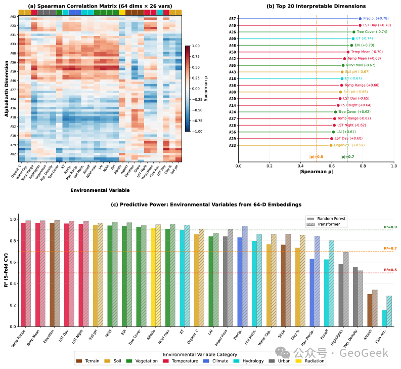
Figure 1 · Recognizable physical semantics have formed within the AlphaEarth embedding. The figure maps 64 embedding dimensions to 26 environmental variables and compares how well the complete embedding reconstructs those variables. The embedding space retains information about thermal environment, vegetation structure, forest cover, hydrologic cycling, temperature background, and broader precipitation–topography–vegetation gradients. A40 is most closely associated with daytime land-surface temperature; A48 with vegetation structure and canopy productivity; A26 with forest cover and woody vegetation; A00 with hydrologic cycling; A50 with mean-temperature background; and A57 with a combined gradient linking precipitation, wetness, topography, and vegetation productivity (Rahman, arXiv, 2026, Fig. 2).
02 · Vegetation semantics
A48 corresponds to vegetation structure and canopy productivity. It is strongly related to EVI, LAI, NDVI, and related variables. NDVI primarily records greenness, EVI remains more responsive in high-biomass conditions, and LAI measures leaf area and canopy structure. Because A48 is associated with all of them, it is better understood as an integrated vegetation-structure dimension than as a substitute for any single vegetation index.
A26, by contrast, is more strongly associated with tree cover and woody vegetation. It points less to short-term greenness than to persistent land-cover structure and the distribution of woody vegetation. This distinction matters: forest cover is not the same quantity as annual vegetation condition; it is closer to long-term ecological structure, land-use context, and habitat type.
The difference between A48 and A26 indicates that vegetation semantics in AlphaEarth are layered. A48 leans toward canopy condition, productivity, and within-year vegetation structure; A26 leans toward forest cover, woody vegetation, and relatively stable land-cover type. Conventional remote-sensing analysis often has to construct vegetation indices, canopy-structure variables, and land-cover variables separately. AlphaEarth appears to compress these kinds of information into different semantic directions in embedding space.
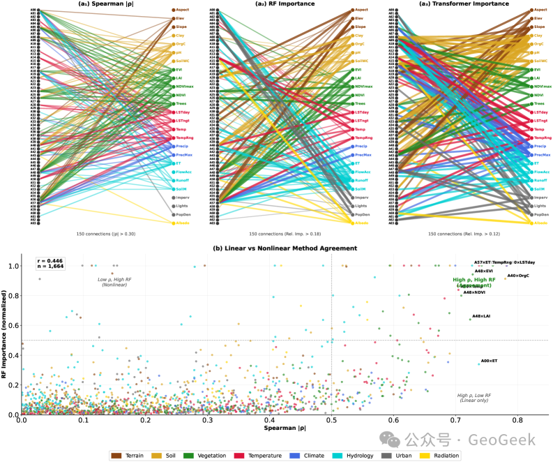
Figure 2 · Several interpretive methods converge on a subset of embedding semantics. Spearman correlation, Random Forest importance, and Transformer-based interpretation do not assign identical meanings to every dimension, but several relationships recur across methods: A57 with precipitation and wetness gradients; A40 with daytime land-surface temperature; A48 with vegetation structure; A26 with tree cover; A50/A42 with mean temperature; and A14/A28 with nighttime land-surface temperature. Not every dimension is understood, but a subset shows comparatively stable physical semantics (Rahman, arXiv, 2026, Fig. 3).
03 · Hydrologic semantics
A57 corresponds to a combined gradient involving precipitation, wetness, topography, and vegetation productivity. In the paper, its strongest relation is with annual precipitation, but it also covaries with LAI, dew-point temperature, and elevation. Annual precipitation represents water input; dew point reflects atmospheric moisture; LAI reflects vegetation productivity; and elevation structures climate and precipitation regimes. Their joint relation to A57 suggests that the dimension is closer to a climate–topography–vegetation gradient than to any single environmental variable.
A00 is associated with a different structure: evapotranspiration, precipitation, and soil moisture together. It should not be reduced to "moisture" or "precipitation." It appears closer to a composite hydrologic signal that reflects the joint variation of water input, vegetation water use, soil storage, and atmospheric evaporative demand.
This is among the most informative results in the study. Land-surface systems are not collections of independent variables. Precipitation, terrain, vegetation, soil moisture, and evapotranspiration are tightly coupled. The importance of A57 and A00 is therefore not merely that they correlate with environmental measurements, but that they appear to capture parts of the structured relation among hydroclimate, terrain, and vegetation productivity.
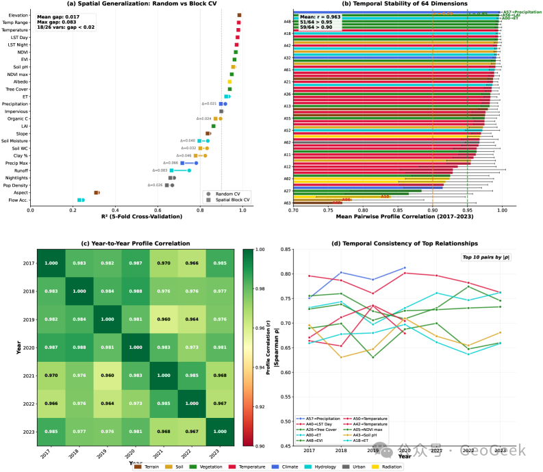
Figure 3 · Some AlphaEarth physical semantics show spatial transferability and interannual stability. Spatial-block cross-validation indicates that many environmental variables remain reconstructable after reducing information leakage from neighboring samples. Analysis across 2017–2023 also shows that strong relationships such as A57–precipitation and A40–daytime land-surface temperature remain comparatively stable through time. This makes it less likely that these relationships are merely artifacts of one year or local spatial correlation (Rahman, arXiv, 2026, Fig. 4).
What this changes
AlphaEarth's embedding space is not a wholly uninterpretable black box. This study provides one of the first systematic demonstrations that several dimensions have stable relationships with land-surface thermal conditions, vegetation structure, forest cover, hydrologic cycling, and broader climate–topography–vegetation gradients:
A40 corresponds to daytime surface thermal state. A50, A42, A14, and A28 capture different aspects of regional temperature background and nighttime thermal conditions. A48 represents vegetation structure and canopy productivity. A26 is associated with forest cover and woody vegetation. A57 tracks a combined precipitation–wetness–topography–productivity gradient. A00 is associated with the coupled variation of evapotranspiration, precipitation, and soil moisture.
Three cautions remain important. First, only a small fraction of the 64 dimensions currently have robust interpretations; most of the embedding remains opaque. Second, the empirical analysis is confined to the conterminous United States, so the identified embedding–environment relationships should not be assumed to be globally stable. Third, correlation is not causation. A48 may be strongly associated with LAI, but A48 is not LAI. It is an interpretable proxy feature and should not simply replace a physical variable in mechanistic inference.
The black box has not been opened completely. But AlphaEarth can now be understood as something more than an efficient feature extractor: it is beginning to look like a semi-transparent land-surface representation. The same embedding can also be queried by an LLM-based system, as in the paper's Land Surface Intelligence demonstration, which can answer physically meaningful questions such as where conditions are simultaneously hot and dry.
AlphaGo showed how machine intelligence could master a formal game. AlphaFold showed that learned representations could transform structural biology. AlphaEarth is beginning to establish interpretable links to the physical world. The more consequential question now is whether those links can remain stable across geography, scale, and time.