When Nature Disagrees with Nature: The Observation Problem in Remote Sensing
Two apparently conflicting studies of Amazon seasonality expose two different failures of remote sensing: seeing a signal created by geometry, and failing to sample enough of the phenomenon.
- Reference
- notes:n16
- Published
- 2026.04.12
- Series
- note
- Source
- Source ↗
Remote-sensing time series are increasingly treated as direct evidence of surface change. That practice rests on a dangerous premise: what a satellite records is not always equivalent to what the surface itself has changed.
The long-running debate over seasonality in Amazon evergreen forest is a useful example. A 2014 paper in Nature and a 2021 paper in Nature Communications appear, at first glance, to reach conflicting conclusions. The first argued that the dry-season green-up seen in earlier optical remote-sensing records was largely an artefact of changing sun–sensor geometry. The second, using high-frequency geostationary observations, found detectable seasonality across much of the Amazon evergreen forest.
The papers are less contradictory than they look. Together they expose two weak points in remote-sensing evidence: sometimes we see the wrong thing; sometimes we simply do not see often enough.
01 · When remote sensing sees the wrong thing
Morton et al. (2014) is often summarized as showing that the Amazon does not green during the dry season. That is not quite the point. Their stronger claim was that the apparent green-up visible in earlier optical remote-sensing products could not be interpreted directly as an increase in leaf area, a genuine change in leaf reflectance, or an increase in productivity.
The authors evaluated several possible mechanisms and concluded that the apparent green-up was driven mainly by seasonal changes in near-infrared reflectance associated with sun–sensor geometry. Once bidirectional-reflectance effects were normalized, the strong seasonal signal largely disappeared. Independent lidar observations and three-dimensional radiative-transfer simulations were consistent with that interpretation.
An index changing is not the same thing as a forest changing. Over strongly anisotropic tropical canopies, an optical time series that has not been rigorously normalized for geometry should not pass directly into ecological interpretation.
The conclusion was not based on a single product. The analysis combined the FLIGHT three-dimensional radiative-transfer model, ICESat/GLAS lidar observations, and monthly pixel-level BRDF inversions from Terra and Aqua MODIS reflectance. On that basis, the authors argued that there was no regional evidence for a coherent seasonal change in canopy structure or intrinsic reflectance across southern Amazon forests.
The study also identified a particularly dangerous form of error: a directional systematic bias. During the Amazon dry season, MODIS observing geometry moves progressively closer to the principal plane. Seasonal change in geometry alone can make simulated NIR and EVI appear to increase through the dry season. Once the geometry is standardized, the apparent trend weakens sharply or disappears.
This is one of the more treacherous failure modes in remote sensing. The problem is not random noise. The error varies smoothly with the season, follows a physically structured pattern, and may align with the ecological story the researcher already expects to see. It can therefore look more convincing than noise precisely because it is systematic.
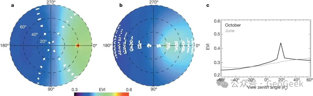
Figure 1 · The central warning from the 2014 Nature paper: over a strongly anisotropic canopy such as the Amazon, seasonal changes in sun–sensor geometry can themselves generate an apparent dry-season green-up.
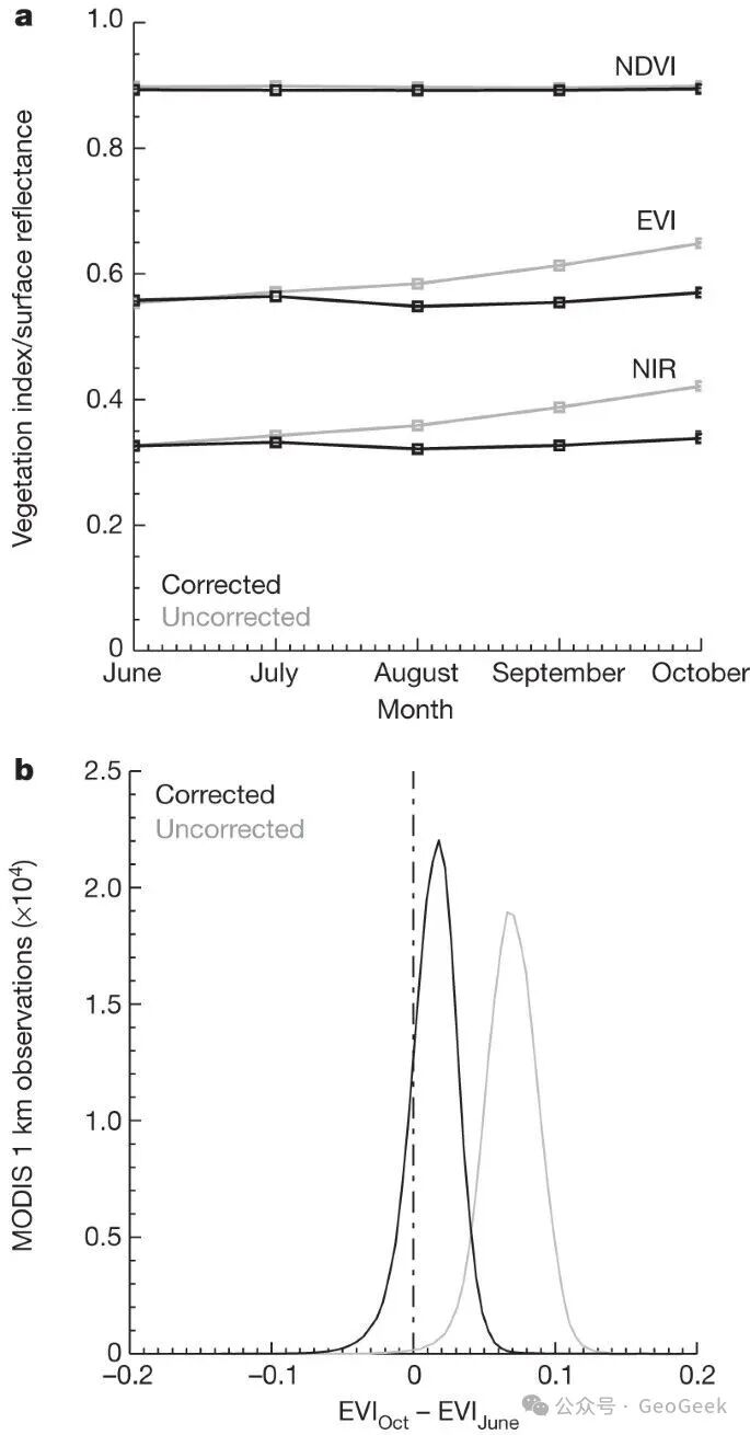
Figure 2 · Without geometric normalization, MODIS NIR and EVI show a pronounced dry-season green-up. Under a standardized sun–sensor geometry, the seasonal signal weakens markedly or disappears.
02 · When remote sensing has not looked often enough
The 2021 Nature Communications paper by Hashimoto et al. advanced the problem in a different direction. Even after geometric effects are recognized, older sun-synchronous satellites can still be inadequate in a persistently cloudy region such as the Amazon because they may simply not provide enough cloud-free observations.
Hashimoto et al. used GOES-16 ABI observations to analyze NDVI seasonality in Amazon evergreen forest during 2018–2019. Unlike a sun-synchronous sensor such as MODIS, ABI can revisit the same area every 10–15 minutes. The authors obtained roughly 21–35 times as many cloud-free observations as MODIS and detected statistically significant seasonality across about 85% of Amazon evergreen forest—an area roughly three times larger than in earlier MODIS-based analyses.
If a pixel has only a few valid clear-sky observations during the critical part of the season, no amount of elaborate compositing or curve fitting can create evidence that was never observed. In the Amazon, sampling density is not a minor engineering detail. It is part of the validity conditions of the ecological conclusion.
The problem is also not merely “too few observations.” In chronically cloudy tropical regions, low observation frequency makes it harder to obtain a sufficiently stable and consistent clear-sky sample. This becomes both a sampling problem and a screening problem. If the valid observations are too sparse, a genuine seasonal signal can be weakened, distorted, or missed entirely.
The 2021 paper should therefore not be read as a simple refutation of the 2014 paper. It says something more useful: even after angle effects are recognized and corrected, the observation opportunity itself may still be inadequate for a reliable answer.
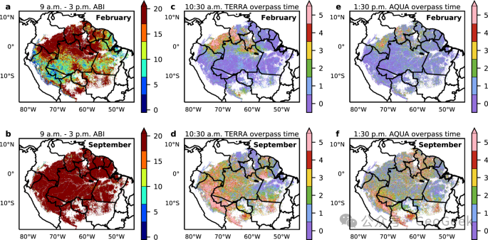
Figure 3 · The key addition from the 2021 Nature Communications study: the question is not only whether the satellite may see the wrong signal, but whether it has sampled often enough. Persistent cloudiness leaves sun-synchronous satellites with too few clear-sky observations in much of the Amazon.
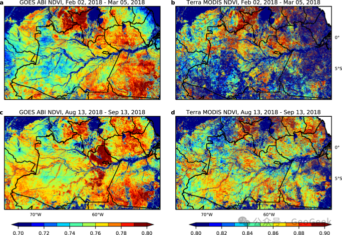
Figure 4 · When the number and timing of clear-sky observations differ, monthly NDVI composites from ABI and MODIS can produce substantially different spatial patterns.
03 · The boundary of remote-sensing evidence
Read together, the two papers are more informative than a simple “one says yes, the other says no.” They identify two recurring forms of remote-sensing failure: misinterpretation and insufficient observation.
Seeing the wrong thing does not mean the instrument is broken or that the data are excessively noisy. It means that a non-target factor—view geometry, angular effects, atmosphere, or processing—enters the time series in a form that resembles genuine change. The most dangerous such errors are smooth, stable, and ecologically plausible.
Not seeing enough is likewise more than having a slightly smaller sample. If valid observations are too sparse during the period that matters, the time series lacks a sufficiently strong evidential basis. Subsequent compositing, fitting, and statistical testing may simply manipulate a handful of samples and either attenuate, distort, or miss the real signal.
One failure mode mistakes a non-surface signal for a surface process. The other enters interpretation before the evidence is sufficiently sampled. One tends toward false positives, the other toward false negatives.
The difficult question in remote sensing is often not whether a time series can be drawn, but whether the time series deserves to be believed before ecological meaning is assigned to it.
References
- Morton, D. C., Nagol, J., Carabajal, C. C., Rosette, J., Palace, M., Cook, B. D., Vermote, E. F., Harding, D. J. & North, P. R. J. Amazon forests maintain consistent canopy structure and greenness during the dry season. Nature 506, 221–224 (2014).
- Hashimoto, H. et al. New generation geostationary satellite observations support seasonality in greenness of the Amazon evergreen forests. Nature Communications 12, 684 (2021).